Shifting bioclimates and the trajectory of global agricultural landscapes

Future_Ag_EnS is a global dataset and AI-powered web platform that describes how the bioclimatic conditions of the world's cropland are projected to shift under climate change. It covers 46 crops at a resolution of about 1 km, under 16 near-term and mid-century CMIP6 scenarios. The platform answers queries for any crop, scenario and region, from the globe to the district level.

Open the platform

Climate change and the bioclimatic basis of crop production

The conditions in which the world's crops are grown are shifting as the global climate changes. Each crop is grown within a characteristic range of bioclimatic conditions: a particular combination of growing-season energy, water availability and the seasonality of both. Whether the land now under a crop will keep those conditions is a pressing question for farmers and agronomists, for crop breeders, and for those responsible for food security and adaptation planning.

Climate change is already affecting food production world-wide, and the emergence of climate impacts on the global food supply is now already on the horizon. The unique set of bioclimatic conditions enabling crop production on the world's cropland will continue to shift for the foreseeable future.

Adaptation that responds only after change has arrived will fall behind it. A move from reactive to anticipatory planning is needed: breeding, management, water relations and the choice of crops and systems must be planned for the conditions toward which climates are moving, rather than for the climate of the past.

Knowing where and how growing conditions are shifting allows farmers, land managers, agronomists, crop breeders, extension services, and policy makers to build that change into their decisions, from the choice of crop on a single farm to national adaptation plans and agricultural policy.

Crop bioclimatic envelopes and four classes of cropland

The analysis rests on a global bioclimatic stratification, which divides the land surface into 125 strata of similar bioclimatic conditions on a grid of about 1 km. The same strata are mapped under the present climate and under each future scenario. The envelope of a crop is the set of strata in which that crop is grown today. For each crop and scenario, every hectare of the crop's cropland falls into one of four classes:

Stable

The projected climate stays inside the range of the current crop envelope.

At the extreme

The land stays in a stratum of the crop's envelope, but its projected climate is at the extreme of that stratum's range.

Existing stratum outside the envelope

The land moves to a stratum outside the crop's envelope.

Novel conditions

The projected climate is novel: its bioclimatic conditions resemble those of no present-day stratum.

Cropland by mid-century

Under the focal scenario (Consensus ensemble, SSP3-7.0, 2041–2060):

1,160.5 Mhacropland analysed, 46 crops
62.8%stable
22.8%at the extreme
14.4%outside the envelope (166.8 Mha)
152.6 Mhain novel conditions, with no present-day counterpart

Much of this land will enter novel climatic conditions with no present-day counterpart.

Explore the results

A query names a crop, a region and a scenario, or is typed as a question in plain language, for example:

"How will climate change affect pearl millet in Western Africa by mid-century?"

The platform returns:

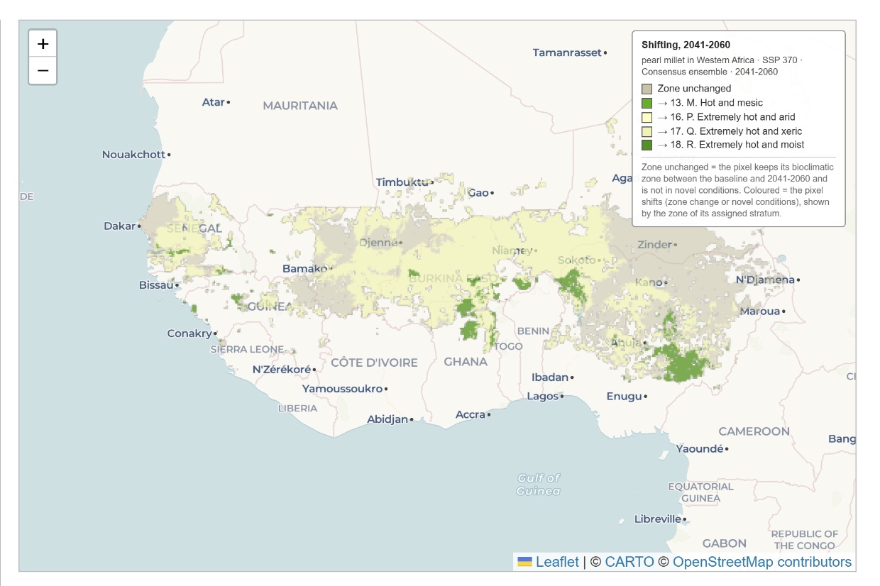
Example map from the platform: pearl millet cropland in Western Africa under SSP3-7.0, Consensus ensemble, 2041–2060. Land whose bioclimatic zone is unchanged is shown in grey; land shifting to the hot and mesic, extremely hot and arid, extremely hot and xeric, or extremely hot and moist zones is shown in greens and pale yellows.
Example of a map returned by the platform: pearl millet in Western Africa, SSP3-7.0, Consensus ensemble, 2041–2060.
  • a summary in plain language
  • a map
  • tables
  • a report

Results are available for 46 crops and 16 scenarios, from the globe to the district level. The summaries are written by a large language model from the values the platform serves for the query, and include region specific context.

Open the platform

Publications

The Future_Ag_EnS platform

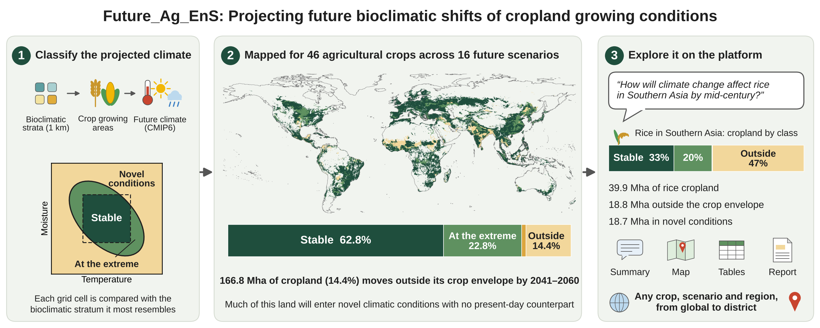
Graphical abstract of the Future_Ag_EnS platform paper: classify the projected climate, map it for 46 crops across 16 scenarios, and explore it on the platform. Submitted

Zomer, R.J., Metzger, M.J., Trabucco, A. Future_Ag_EnS: AI-powered platform exploring climate change impacts on global cropland and food security. Submitted to Environmental Modelling & Software.

Describes the dataset and the web platform. Cropland of 46 crops is classed as stable, at the extreme of the crop's range, or outside its envelope, under 16 scenarios, and the results can be queried for any crop, scenario and region, with summaries in plain language.

Global staple food production

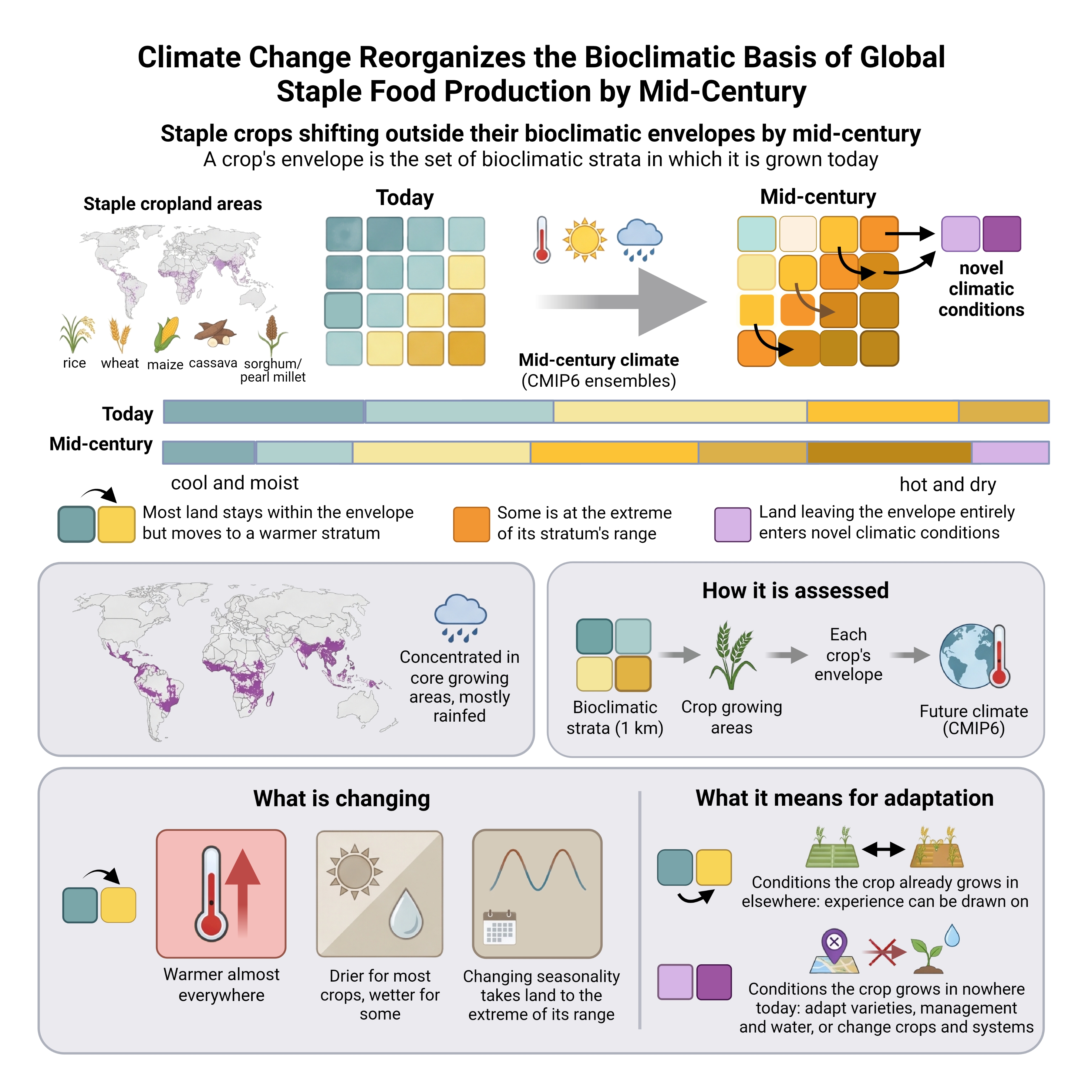
Graphical abstract of the staple crops paper: staple crops shifting outside their bioclimatic envelopes by mid-century, with maps of staple cropland, the bioclimatic strata today and at mid-century, how the change is assessed, what is changing, and what it means for adaptation.

Created in BioRender. Zomer, R. (2027) https://BioRender.com/dwu1f9z

Under Review

Zomer, R.J., Metzger, M.J., Debolini, M., Xu, J., Trabucco, A. Climate change reorganizes the bioclimatic basis of global staple food production by mid-century. Under review at One Earth.

By mid-century (2041–2060), under the focal scenario (SSP3-7.0), 108 million hectares (15%) of staple cropland lies outside its crop's bioclimatic envelope, nearly all in novel climatic conditions, 78% in core production regions and 68% rainfed. A further 25% lies at the extreme of its stratum's range, and most of the rest moves to a warmer stratum.

The Future Global EnS

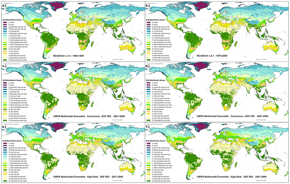
Six global maps of the bioclimatic zones of the environmental stratification: two historical baselines (1960–1990 and 1970–2000) and the Consensus and High Risk ensembles under SSP5-8.5 for 2021–2040 and 2041–2060.

Zomer, R.J., Metzger, M.J., Xu, J., Trabucco, A., 2025. High resolution global environmental stratification to model shifting bioclimatic conditions and climate change impacts on terrestrial ecosystems. Open Research Europe 5, 193.

This study presents a global application of the Environmental Stratification (EnS) methodology, integrating outputs from 22 CMIP6 Earth System Models across four Shared Socioeconomic Pathways, two historical baseline climate datasets and two future averaged time periods (2021–2040; 2041–2060). The resulting Future_Global_EnS Database provides these high-resolution EnS projections at 30 arc seconds resolution (~1 km²). The global EnS analysis reveals extensive bioclimatic reorganization by mid-century.

Related publications

Global Aridity Index and PET, Version 3

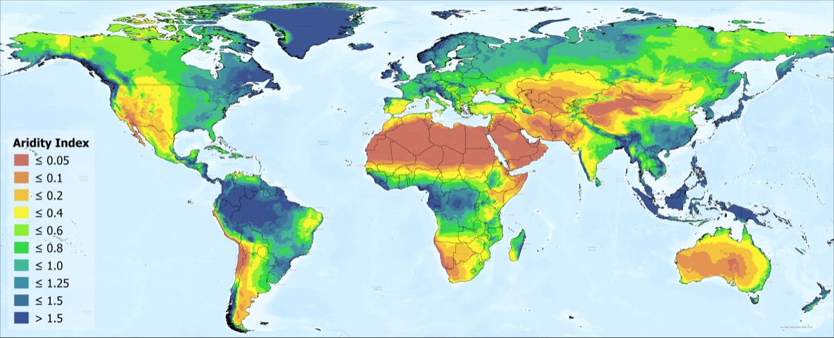
Global map of the Aridity Index from the Global Aridity Index and Potential Evapotranspiration Database.

Zomer, R.J., Xu, J., Trabucco, A., 2022. Version 3 of the Global Aridity Index and Potential Evapotranspiration Database. Scientific Data 9, 409.

The Global Aridity Index and Potential Evapotranspiration Database, Version 3 (Global-AI_PET_v3) provides high-resolution (30 arc-seconds) global hydro-climatic data averaged (1970–2000) monthly and yearly, based upon the FAO Penman-Monteith Reference Evapotranspiration (ET0) equation.

Future Global Aridity Index and PET (CMIP6)

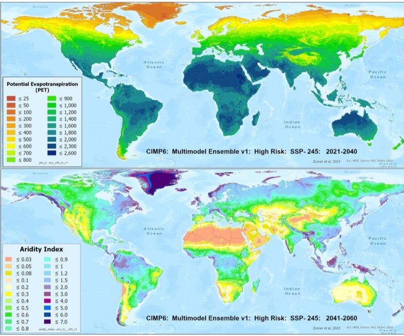
Global maps of potential evapotranspiration for 2021–2040 and of the Aridity Index for 2041–2060, High Risk CMIP6 multi-model ensemble under SSP2-4.5.

Zomer, R.J., Xu, J., Spano, D., Trabucco, A., 2025. CMIP6-based global estimates of future aridity index and potential evapotranspiration for 2021-2060. Open Research Europe, Article 157 (original work published 2024).

The Future_Global_AI_PET Database provides high-resolution (30 arc-seconds) average annual and monthly global estimates of potential evapotranspiration (PET) and aridity index (AI) for 22 CMIP6 Earth System Models, for two historical (1960–1990; 1970–2000) and two future (2021–2040; 2041–2060) time periods, under four shared socio-economic pathways. Three multimodel ensembles are provided, outlining the different levels of risk space.

Global bioclimatic redistribution

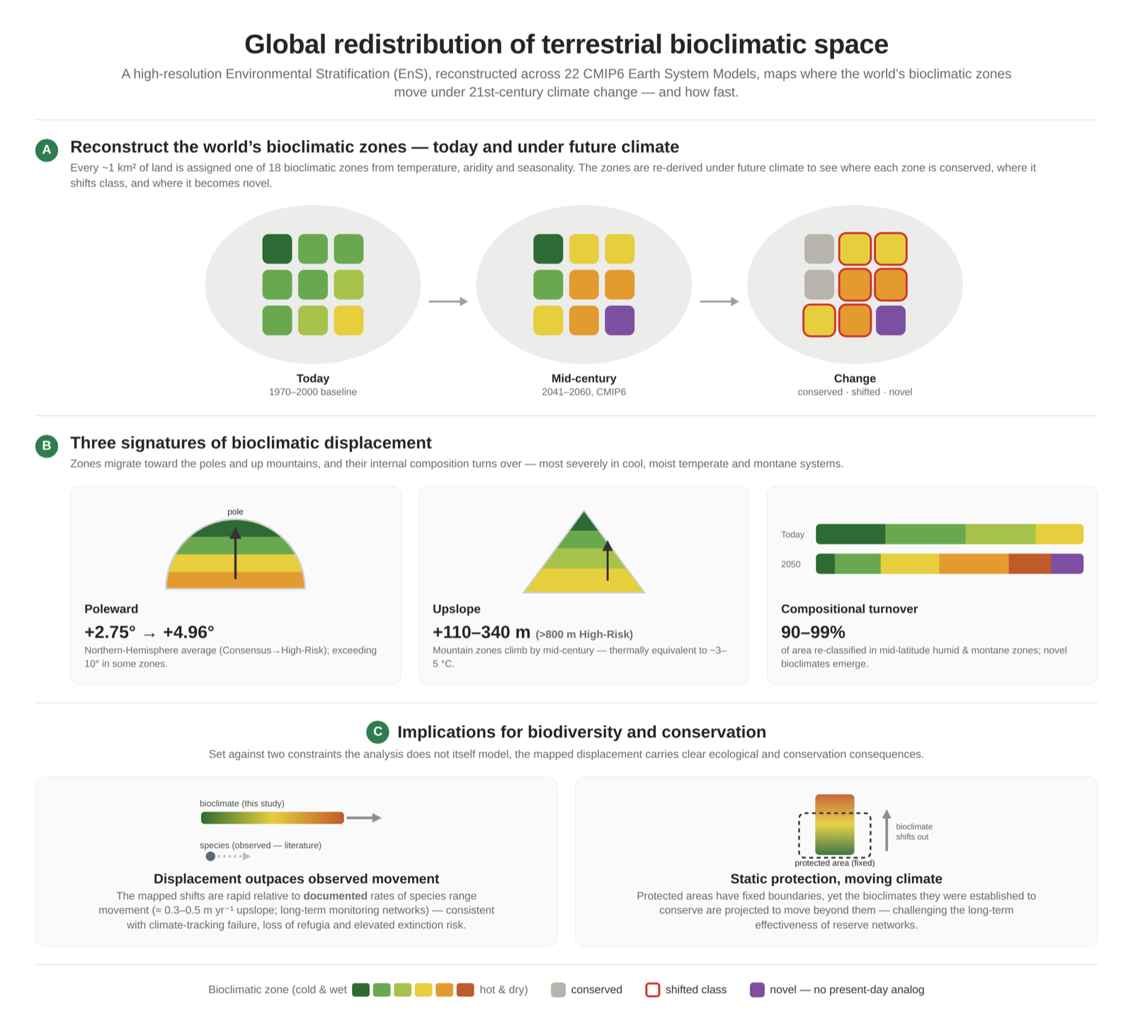
Graphical abstract, Global redistribution of terrestrial bioclimatic space: the world's bioclimatic zones today and at mid-century, three signatures of displacement (poleward, upslope and compositional turnover), and implications for biodiversity and conservation. Under Review

Zomer, R.J., Metzger, M.J., Xu, J., Trabucco, A. Global bioclimatic zones shift poleward and upslope with high compositional turnover by mid-century. Under review at Environmental Research: Climate.

A statistically derived environmental stratification of the global land surface, 125 bioclimatic strata aggregated into 18 zones at 30 arc-second (~1 km) resolution, is applied to 22 CMIP6 Earth System Models across four Shared Socioeconomic Pathways and two future periods (2021–2040; 2041–2060). Bioclimatic zones migrate poleward by 2.75–4.96° on average in the Northern Hemisphere and upslope by 110–340 m, and compositional turnover reaches 90–99% in mid-latitude humid and montane zones. Displacement rates exceed documented rates at which species and communities track climate, indicating refugia loss and elevated extinction risk.

Databases

Global Aridity Index and PET Database

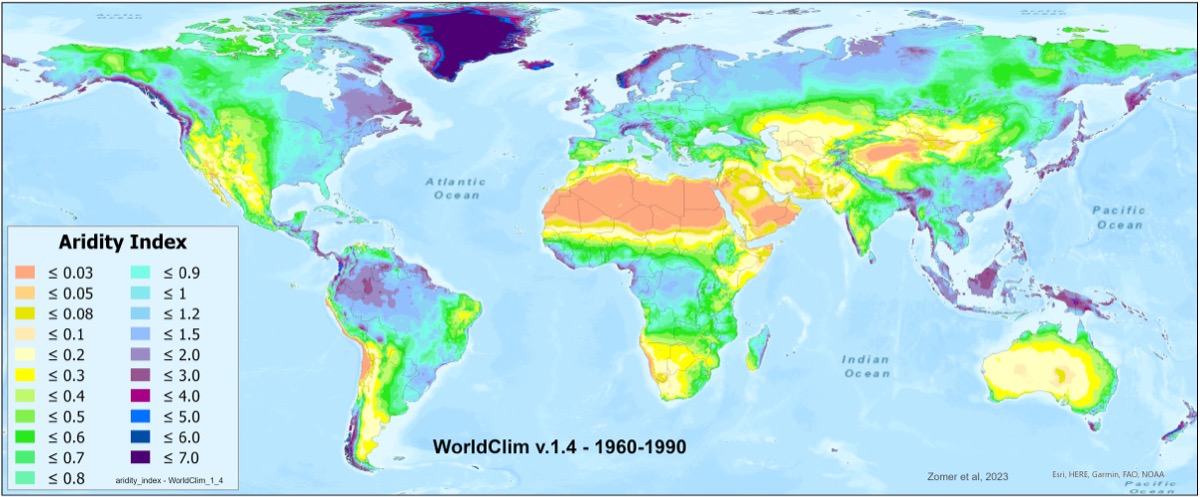
Global map of the Aridity Index, WorldClim v.1.4, 1960–1990, from the Global Aridity Index and PET Database.

The Global Aridity Index and Potential Evapotranspiration (Global AI-PET) Database provides high-resolution global geospatial raster data related to evapotranspiration processes and rainfall deficit for potential vegetative growth. The Global_AI_PET (v.3) Database for 1970–2000 implements the FAO Penman-Monteith Reference Evapotranspiration (ET0) equation, providing monthly and annual averages of reference evapotranspiration and the aridity index at 30 arc-seconds resolution. The Penman-Monteith method accounts for temperature, solar radiation, wind speed and humidity, and is the standard recommended by the FAO for estimating reference evapotranspiration.

Future Global Aridity Index and PET Database (CMIP6)

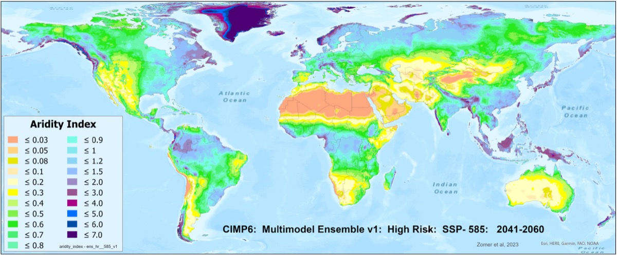
Global map of the Aridity Index projected for 2041–2060 under SSP5-8.5, High Risk CMIP6 multi-model ensemble, from the Future Global Aridity Index and PET Database.

The Future_Global_AI_PET Database provides high-resolution (30 arc-seconds) global geospatial raster data of average monthly and annual potential evapotranspiration (PET) and an aridity index (AI) for two historical (1960–1990; 1970–2000) and two future (2021–2040; 2041–2060) time periods, for each of 22 CMIP6 Earth System Models across four emission scenarios. Three averaged multi-model ensembles are included for each scenario.

Future_Global_EnS: CMIP6 Global Environmental Stratification Database

Six global maps of the bioclimatic zones of the environmental stratification: two historical baselines (1960–1990 and 1970–2000) and the Consensus and High Risk ensembles under SSP5-8.5 for 2021–2040 and 2041–2060.

The Future_Global_EnS Database provides a set of high-resolution (30 arc-seconds) global raster datasets of bioclimatic zones and strata produced using the Environmental Stratification (EnS) methodology, for two historical (1960–1990; 1970–2000) and two future (2021–2040; 2041–2060) time periods, for each of 22 CMIP6 Earth System Models across four emission scenarios. Two multi-model averaged ensembles, Consensus and High Risk, are included.

Team

  • Robert J. Zomer: CMCC Foundation - Euro-Mediterranean Center on Climate Change, Lecce, Italy; Centre for Mountain Futures, Kunming Institute of Botany, Chinese Academy of Sciences, Kunming, China
  • Antonio Trabucco: CMCC Foundation - Euro-Mediterranean Center on Climate Change, Lecce, Italy; National Biodiversity Future Center (NBFC), Palermo, Italy

Contact: robert.zomer@cmcc.it

Funding

This research was supported by a variety of organizations over many years, most recently by the European Union’s Horizon 2020 Research and Innovation Programme (TRANSFORMAR, Grant No. 101036683; NEXOGENESIS, Grant No. 101003881), the European Union’s Horizon Europe Research and Innovation Programme (DRYAD, Grant No. 101156076; ECONATURES, Grant No. 101286604) and the National Recovery and Resilience Plan of the Italian Ministry of University and Research funded by NextGenerationEU (NBFC, Grant No. CN_00000033).

Funded by the European Union. Views and opinions expressed are however those of the author(s) only and do not necessarily reflect those of the European Union or the European Research Executive Agency. Neither the European Union nor the granting authority can be held responsible for them.

Funded by the European Union CMCC Foundation - Euro-Mediterranean Center on Climate Change ECONATURES NEXOGENESIS: Streamlining water related policies National Biodiversity Future Center NBFC Land Mountain Futures World Agroforestry Centre: Transforming lives and landscapes